
American Bad Dream: GeoGuessr Edition

A map of the United States that proves the four-color theorem and contains postal abbreviations for each state. Image from Wikipedia.
The United States was not built with GeoGuessr players in mind.
Now, to be clear, the engineers, architects, and blue-collar construction workers who brought the country’s infrastructure to life (even with all the problems it’s brought us) were under no obligation to make matters convenient for future players of a computer game. They had enough problems as it was.
The fact remains, however, that the way this country’s infrastructure was set up renders it very difficult to tell what state you’re in on Google Street View. In other words, region-guessing the United States can turn into an American Bad Dream.
I am aware that the Kane Brown song “American Bad Dream” is about gun violence, a topic that isn’t funny at all. Indeed, it’s horrendously tragic that we’ve lost so many people to so many acts of it. That’s far worse than whatever happens to people as a result of playing GeoGuessr
But let’s look at some maps, shall we? It’ll tickle the ‘tism, as someone in one of my Discord servers put it. And it’s always fun to do that!
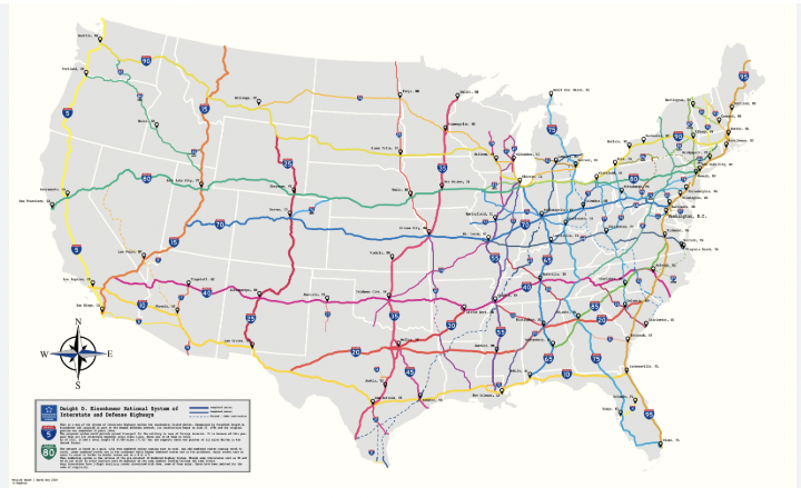
A map of some interstate highways in the United States. Image taken from r/MapPorn.
If you know the general pattern of the Interstate system, conceived by President Eisenhower (or at least, named after him), you can narrow your guess down pretty effectively. The numbering scheme was at least designed in an intuitive manner. It was really a pretty remarkable feat of engineering and one thing to almost be proud of if you live here. More on that later.
Anyway, even-numbered highways run east to west across the contiguous 48 states, and their numbers increase from south to north. They show up on the mini-map you use to send your guess, so you don’t necessarily need to memorize them. As for the odd-numbered highways, they run north to south, with numbers increasing as you move eastward. Again, they’re on the mini-map, so it shouldn’t be too overwhelming.
However, it gets more difficult when you consider state highways. Much more difficult. But as with the interstates, there is at least some method to this madness. This article lays it out more vividly than I feel like doing. However, these state routes (not to be confused with “interstates” that happen to only be in one state) are given triple-digit numbers according to a different scheme. That scheme varies according to the state, so it’s of only so much use if you don’t already have a good idea what state you’re in.
And the highway numbers are all the help you’ll get in terms of infrastructure!

A gallery of license plates for all 50 US States as of 2023. Image taken from r/coolguides.
These are the current license plates for every state. At least, they’re the most current plates I was able to find. And of course, in the last few years some states have changed their plate design for a number of reasons (sometimes adjacent to being more sensitive to racial issues). This means that sometimes, especially in older coverage, you’re going to see previous designs of license plates. For our purposes, suffice it to say that it’s a pain in the ass trying to memorize them all. A lot of them look fairly similar to each other.
There are also a few reasons why license plate meta is only so useful in the United States. First of all, most license plates are blurred on Google Street View. That’s not even exclusive to the USA. If you can recognize any distinguishing features of license plates beyond color through the blur, you’ve got better eyes than me. Either that, or you’re going to strain your eyes to an extent that’s not worth it for a mere computer game.
But wait! There’s more!
You see, infrastructure in the United States is very often centered around automobiles to an unhealthy extent. This is in no small part due to the interstate system; for all the economic growth it has brought the country over the years, GDP isn’t everything. Hell, some people would argue that GDP doesn’t matter very much at all, and what you should really be measuring is how the people in the middle class and below are doing. It’s also true that these highways were often built through marginalized communities, particularly those where disproportionately many people of color lived. This is a problem that, in a perfect world, would be alleviated somehow.
The reason I say this is because, even more than in countries with considerably less car-centric infrastructure, cars travel. That’s kind of why they exist. This means that you’ll often see license plates from states besides the one you’re in, particularly if you spawn on a highway.
In fact, the “long road trip” has been a common element of American popular culture for quite some time. I was never one for such trips because I hate sitting in a car for hours on end, but plenty of families still do them. The “license plate game”, in which bored family members compete to see who can spot vehicles from the most states, is also a figment of the public consciousness. So basically, license plates aren’t terribly useful for region-guessing the USA.
If you thought license plates were confusing, you’re in for a rude awakening.

A map of telephone area codes in the contiguous United States. Image taken from All Area Codes dot com.
Holy hell.
Just look at that. It’s a monstrosity. If you try to memorize them all, you might well find yourself locked in a padded room painting the wall with your own excrement. Unless your name is Trevor Rainbolt, of course.
In most other countries covered by GeoGuessr, telephone area codes make sense. At a minimum, they’re ordered in an intuitive manner. In Turkey, for instance, area codes starting with 2 are found in the western part of the country, area codes starting with 3 go in the middle, and area codes starting with 4 are in the east. That’s a reasonable way to order your phone numbers.
Let’s look back at the United States. Hell, let’s just look at my home state of Massachusetts, one of the smallest states geographically that nonetheless packs quite a punch economically. If you’ve narrowed it down to Massachusetts based on architecture, those low stone walls beside the road, or even a sign telling you what state you’re in, you still might see a phone number on an advertisement for a local business.
In Boston and its innermost suburbs, the first three digits of the phone number are 617, so that the number will be 617-XXX-XXXX. Supposedly the next couple of digits are sorted by town, but at that point the walls will smell absolutely rancid due to the resulting insanity. Anyway, correctly guessing the 617 area code will almost invariably get you the win against all but the most insane players.
Just outside of 617, when you get to the outer suburbs and some exurbs, the area code is 781. Where did the 163 numbers in between go? Well, in reality, they’re strewn all over the rest of the USA and Canada like the objects in that Calvin & Hobbes strip about opening a closet.

“Calvin & Hobbes” comic strip from June 23, 1989. If it was set these days, Calvin would probably be asking to play Fortnite, but that’s beside the point. Image taken from GoComics.
In all seriousness, once you’re past 781, you have the 508 area code that serves the Worcester area, Buzzards Bay, Cape Cod, and the islands of Martha’s Vineyard and Nantucket. Northern and northeastern Massachusetts contains the 978 area code, and western Massachusetts (including the Berkshires) uses 413. So there are five area codes, seemingly random numbers, that zigzag around the state.
And remember, that’s just one state, and a pretty small one at that as far as GeoGuessr is concerned! You still have 47 other states to memorize if you’re in the contiguous part of the country!
Look: On the list of things to be ashamed about as an American, making life difficult for GeoGuessr players is pretty far down. I’m not naïve to that fact. If anything, I think it’s pretty interesting stuff, because it serves as evidence that this game takes a lifetime to master.
Additionally, keep in mind that you can learn this information all day long, but you won’t need it very often. In my experience, European and Asian countries show up far more frequently in duels than the United States or Canada. Maybe that’s just me, though. But that’s another thing that makes GeoGuessr so hard, yet so rewarding at the same time.